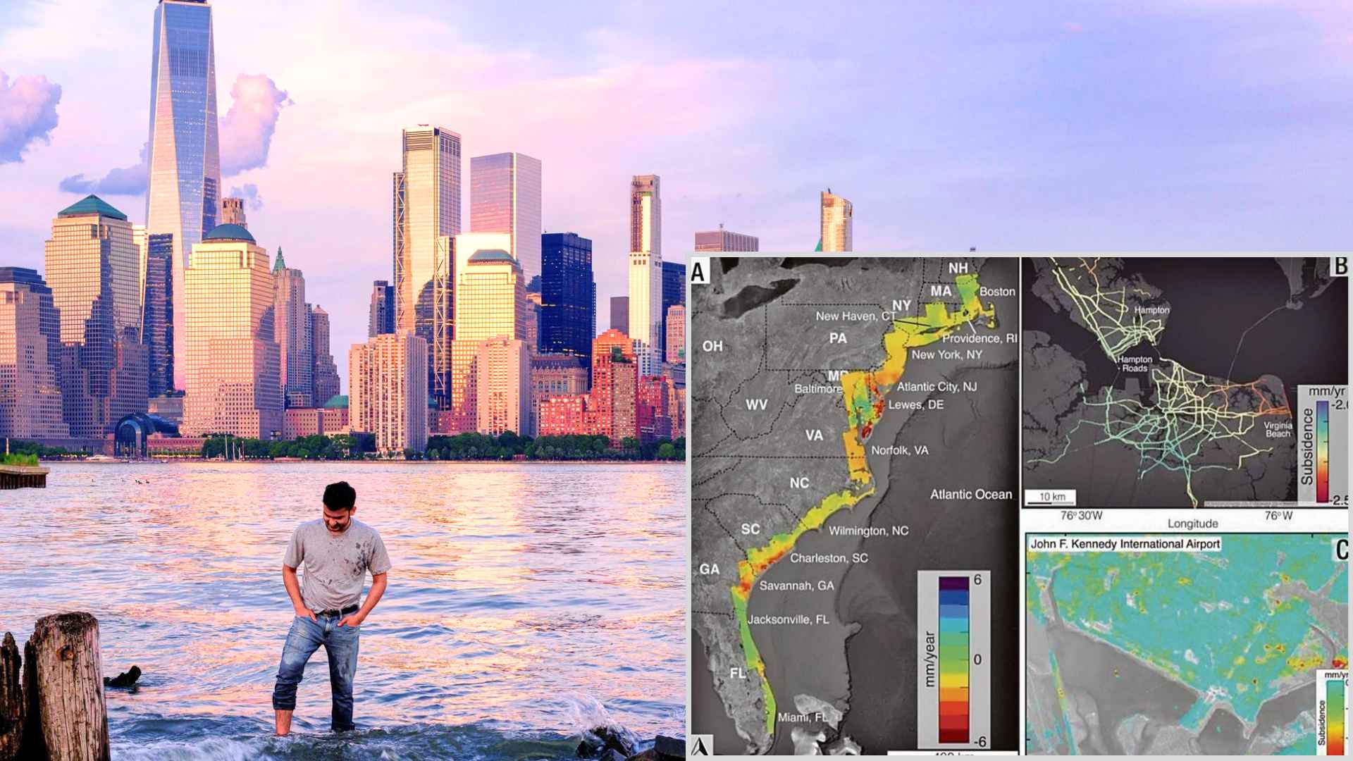
New radar maps show parts of Houston, New York and Chicago settling by up to 10 millimeters a year—enough to stress bridges, roads and even flood defenses.
America’s biggest urban centers are slowly losing altitude, and the change isn’t just academic. A Virginia Tech research team has mapped “subsidence corridors” in the 28 most‑populous cities and found that at least one‑fifth of each city is sinking between two and 10 millimeters (0.08‑0.4 inches) annually. That quiet downward drift, experts warn, can loosen foundations, crack pipelines and magnify flood risks long before the damage becomes obvious.
Satellite data reveals alarming land‑subsidence threat for U.S. cities already facing climate stress
Radar instruments aboard orbiting satellites captured centimeter‑level movements of the ground surface, giving scientists their most detailed look yet at urban subsidence. The analysis shows that in 25 of the 28 cities, at least 65 percent of land is sinking, with Texas metros leading the pack.
Houston stands out: roughly 40 percent of the city settles faster than 5 millimeters per year, and 12 percent drops at a 10‑millimeter clip. “Even slight downward shifts can compromise structures over time,” noted study lead author Leonard Ohenhen.
Why groundwater pumping puts major metropolitan infrastructure at growing risk of hidden failure
What’s driving the slide? In 80 percent of the hot spots, researchers linked the movement to aggressive groundwater extraction. When aquifers are tapped faster than nature can refill them, the overlying soils compress—think of a sponge releasing water and shrinking. Coastal zones then face a double punch: local sinking plus global sea‑level rise.
Inland hubs aren’t off the hook either; uneven settling can snap sewer lines and tilt roadbeds. Ask yourself: could a quarter‑inch drop this year stretch a bridge joint enough to matter five years from now? Cities highlighted for notable subsidence:
- New York City
- Chicago
- Houston
- Dallas
- Denver
Each listed metro shows at least 20 percent of its area subsiding, with measured rates somewhere in the 2‑10 millimeter range.
Steps cities can take now to monitor and slow ongoing subsidence before costs skyrocket
Local leaders are hardly powerless. The study urges three immediate moves:
- Expand continuous satellite and ground‑sensor monitoring to flag new hot spots early.
- Tighten groundwater‑withdrawal limits—especially for industrial users—to let aquifers rebound.
- Integrate subsidence projections into building codes and flood‑risk maps, steering future growth away from the softest soils.
Sound expensive? Consider the alternative: deferred repairs that balloon once roads buckle or levees sag. After all, who wants a sink‑prone freeway surprise during rush hour?
Urban America is literally settling, often imperceptibly, beneath busy streets. Keeping tabs on the pace, curbing excessive pumping and reinforcing vulnerable infrastructure now can save billions—and headaches—later.